At a glance
- Full route
- Dongsaengmal → Eoulmadang → Nongbawi → Oryukdo pier, 4.7 km
- Time
- About 2.5 hours end to end, unhurried
- Getting there
- Metro Line 2, Gyeongseong University·Pukyong National University Station, then bus 20, 22, 24, 27, 39 or 131
- Night lighting
- Dongsaengmal to Eoulmadang, 1.26 km, lit from sunset to 22:00
- Entry
- Free, open year-round, no gate
- Terrain
- Boardwalk, dirt path and stairs, with 4 suspension bridges over cliff sections
The coastal walk most visitors miss
Igidae is a cliffside coastal park between Gwangalli and Oryukdo, and the trail through it is one of the better walks in Busan that most first-time visitors never hear about — it sits just off the route between two places they already know, Gwangalli Beach and Oryukdo Sunrise Park, without being part of either.
The full route runs 4.7 kilometers from Dongsaengmal at the Gwangalli end to the Oryukdo pier, and the city puts the walking time at about two and a half hours unhurried. You don't have to do all of it — the trail has enough distinct sections that doing half and turning back, or starting from either end, both work.
The four landmarks along the route
Dongsaengmal is the western starting point, where two of Korea's long-distance coastal trails — the Galmaetgil and the Haepararang-gil — meet. It's the easiest of the four points to reach by public transit, which makes it the natural place to start if you're coming from Gwangalli or central Busan.
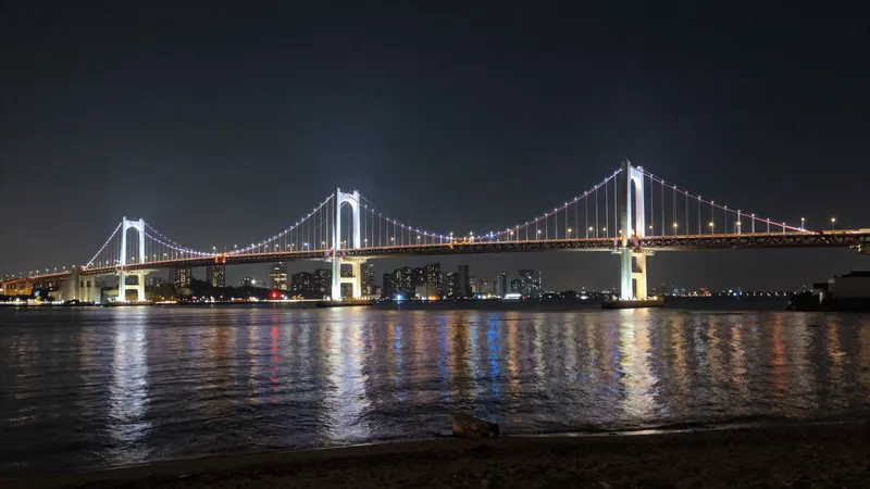
Eoulmadang, 1.26 km along, is the trail's best-known sunrise viewpoint and was a filming location for the Korean film Haeundae. It also marks the end of the night-lit section — the stretch from here back to Dongsaengmal has had installed lighting running from sunset to 22:00 since January 2024, which makes an evening walk on this half of the trail a genuinely different experience from the daytime version.
Nongbawi is the middle stretch, where the trail runs along sea cliffs and wave-cut rock platforms — the part of the walk that's actually about the geology rather than the view. This is also where the trail's four suspension bridges cross over cliff sections, alternating between wooden boardwalk, dirt path and stairs.
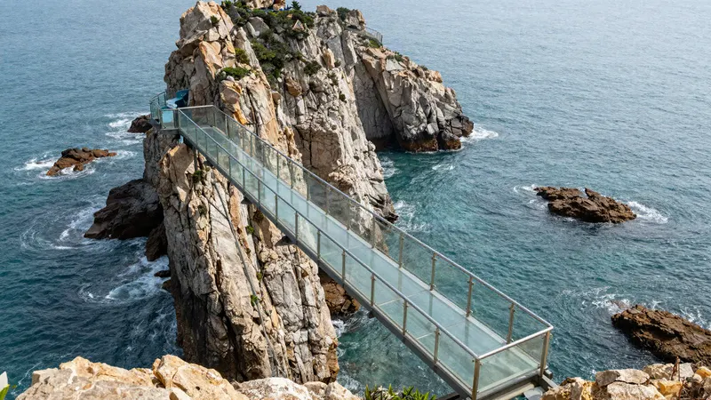
The Oryukdo end connects directly into Oryukdo Sunrise Park and its glass-floor skywalk, and the city describes this end as a spot where sunrise and sunset can both be watched from the same point, depending on the season.
The geology, briefly
Igidae sits inside the Busan National Geopark, and the trail is one of the more accessible ways to actually see what that designation means: sea caves and marine potholes carved into volcanic rock along a stretch the city dates to roughly 80 million years old. None of this needs a guide or an entrance fee to appreciate — the formations are visible from the boardwalk itself, most clearly around the Nongbawi section.
Getting there
For the Dongsaengmal end, take Metro Line 2 to Gyeongseong University·Pukyong National University Station and transfer to bus 20, 22, 24, 27, 39 or 131, or the village buses Nam-gu 2 or Nam-gu 8. This is the more direct approach if you're coming from Gwangalli or central Busan.
For the Oryukdo end, follow the directions in the Oryukdo Skywalk guide and walk the trail in reverse, which works well if you're coming from that side or want the walk to finish rather than start near Gwangalli's restaurants.
Practical notes
- Full boots aren't necessary, but the boardwalk sections get slick after rain — ordinary sneakers with real tread are the right call, not sandals
- The night-lit Dongsaengmal–Eoulmadang stretch (sunset to 22:00) is worth timing a visit around if evenings are what you have free — it's a genuinely different walk after dark
- Combine it with Oryukdo Sunrise Park at one end for a half-day plan, or with Gwangalli Beach at the other for dinner afterward
- There's no shade for most of the route, so treat it the way you'd treat any exposed coastal walk in summer — early morning or evening rather than midday
- Bring water. There are no convenience stores directly on the trail between the two ends
Frequently asked questions
How long is the Igidae coastal trail?
The full route from Dongsaengmal to the Oryukdo pier is 4.7 km, and the city estimates about two and a half hours to walk it unhurried. You don't need to do the whole thing — starting from either end and turning back partway is a normal way to do it.
How do I get to Igidae?
For the Dongsaengmal end, take Metro Line 2 to Gyeongseong University·Pukyong National University Station and transfer to bus 20, 22, 24, 27, 39 or 131. For the Oryukdo end, follow the directions to Oryukdo Sunrise Park and walk the trail in reverse.
Is Igidae lit up at night?
The 1.26 km stretch between Dongsaengmal and Eoulmadang has had installed lighting since January 2024, running from sunset until 22:00. The rest of the trail beyond Eoulmadang is not lit, so plan an evening walk around that section specifically.
Does Igidae connect to Oryukdo Skywalk?
Yes — the trail's eastern end runs directly into Oryukdo Sunrise Park, where the glass-floor skywalk is. Walking the two together makes a natural half-day out, whichever end you start from.
Is there an entrance fee for Igidae?
No. It's a free, open coastal trail with no gate — you walk in from either end and walk out whenever you're done.